IntegratedMeshLayer
require(["esri/layers/IntegratedMeshLayer"], function(IntegratedMeshLayer) { /* code goes here */ });esri/layers/IntegratedMeshLayerThe IntegratedMeshLayer is designed for visualizing accurate representations in a SceneView of infrastructure and natural landscapes that are difficult to access.
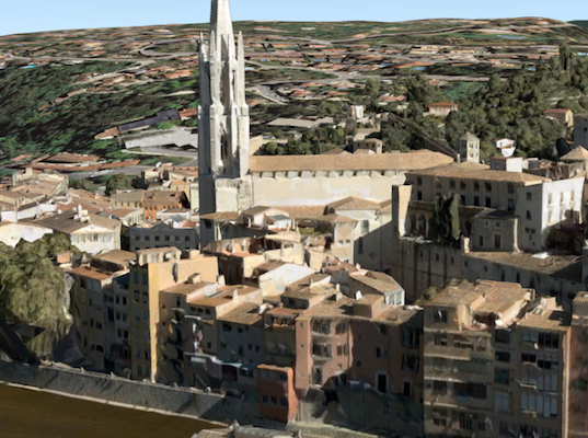
Integrated mesh data is typically captured by an automated process for constructing 3D objects from large sets of overlapping imagery. The result integrates the original input image information as a textured mesh using a triangular interlaced structure. An integrated mesh can represent built and natural 3D features, such as building walls, trees, valleys, and cliffs, with realistic textures. Integrated mesh scene layers will always render in front of the ground surface. They are generally created for citywide 3D mapping and can be created using Drone2Map for ArcGIS, which can then be shared to ArcGIS for Desktop or web apps.
The Scene Service is identified by the URL of the ArcGIS Server REST resource:
IntegratedMeshLayer = new IntegratedMeshLayer({
  url: "https://tiles.arcgis.com/tiles/u0sSNqDXr7puKJrF/arcgis/rest/services/Frankfurt2017_v17/SceneServer/layers/0"
});
If the service is requested from a different domain, a CORS enabled server or a proxy is required.
Constructors
- new IntegratedMeshLayer(properties)
- Parameter:properties Objectoptional
See the properties for a list of all the properties that may be passed into the constructor.
Property Overview
| Name | Type | Summary | Class | |
|---|---|---|---|---|
| String | The copyright text as defined by the scene service. more details | more details | IntegratedMeshLayer | |
| String | The name of the class. more details | more details | Accessor | |
| Object | Specifies how the mesh is placed on the vertical axis (z). more details | more details | IntegratedMeshLayer | |
| Extent | The full extent of the layer. more details | more details | Layer | |
| String | The unique ID assigned to the layer. more details | more details | Layer | |
| Number | The layer ID, or layer index, of a Scene Service layer. more details | more details | IntegratedMeshLayer | |
| String | Indicates how the layer should display in the LayerList widget. more details | more details | Layer | |
| Boolean | Indicates whether the layer's resources have loaded. more details | more details | Layer | |
| Error | The Error object returned if an error occurred while loading. more details | more details | Layer | |
| String | Represents the status of a load operation. more details | more details | Layer | |
| Object[] | A list of warnings which occurred while loading. more details | more details | Layer | |
| Number | The maximum scale (most zoomed in) at which the layer is visible in the view. more details | more details | IntegratedMeshLayer | |
| Number | The minimum scale (most zoomed out) at which the layer is visible in the view. more details | more details | IntegratedMeshLayer | |
| SceneModifications | A collection of SceneModification with polygons and types to apply client-side modifications. more details | more details | IntegratedMeshLayer | |
| PortalItem | The portal item from which the layer is loaded. more details | more details | IntegratedMeshLayer | |
| SpatialReference | The spatial reference of the layer. more details | more details | IntegratedMeshLayer | |
| String | The title of the layer used to identify it in places such as the Legend and LayerList widgets. more details | more details | IntegratedMeshLayer | |
| String | For IntegratedMeshLayer the type is always "integrated-mesh". more details | more details | IntegratedMeshLayer | |
| String | The URL of the REST endpoint of the layer or scene service. more details | more details | IntegratedMeshLayer | |
| Object | The version of the scene service specification used for this service. more details | more details | IntegratedMeshLayer | |
| Boolean | Indicates if the layer is visible in the View. more details | more details | Layer |
Property Details
- copyright String
The copyright text as defined by the scene service.
- Since: ArcGIS API for JavaScript 4.7
The name of the class. The declared class name is formatted as
esri.folder.className.
- elevationInfo ObjectSince: ArcGIS API for JavaScript 4.5
Specifies how the mesh is placed on the vertical axis (z). This property only affects IntegratedMeshLayers when using the
absolute-heightmode. Integrated mesh layers always render in front of the ground surface, so setting negative offset values will not render them below the ground.- Properties:
- mode String
Defines how the mesh is placed on the vertical axis (z). Currently only
absolute-heightis supported.Mode Description absolute-height The mesh is placed at an absolute elevation (z-value) above sea level. This z-value is determined by summing up the offsetvalue and the mesh's z-value. It doesn't take the elevation of the terrain into account. This is the only supported elevation mode for an IntegratedMeshLayer.optionaloffset NumberDefault Value:0An elevation offset, which is added to the vertical position of the mesh.
optionalunit StringDefault Value:metersThe unit for
offsetvalues.Possible Values:"feet"|"meters"|"kilometers"|"miles"|"us-feet"|"yards"
The full extent of the layer. By default, this is worldwide. This property may be used to set the extent of the view to match a layer's extent so that its features appear to fill the view. See the sample snippet below.
Example:// Once the layer loads, set the view's extent to the layer's fullextent layer.when(function(){ view.extent = layer.fullExtent; });
The unique ID assigned to the layer. If not set by the developer, it is automatically generated when the layer is loaded.
- layerId Number
The layer ID, or layer index, of a Scene Service layer. This is particularly useful when loading a single layer with the portalItem property from a service containing multiple layers. You can specify this value in one of two scenarios:
- When loading the layer via the portalItem property.
- When pointing the layer url directly to the Scene Service.
If a layerId is not specified in either of the above scenarios, then the first layer in the service (
layerId = 0) is selected.Examples:// while these examples use a SceneLayer, the same pattern can be // used for other layers that may be loaded from portalItem ids // loads the third layer in the given Portal Item var layer = new SceneLayer({ portalItem: { id: "73df987984b24094b848d580eb83b0fb" }, layerId: 2 });// If not specified, the first layer (layerId: 0) will be returned var layer = new SceneLayer({ portalItem: { id: "73df987984b24094b848d580eb83b0fb" } });// Can also be used if URL points to service and not layer var layer = new SceneLayer({ url: "https://scenesampleserverdev.arcgis.com/arcgis/rest/services/Hosted/DevA_Trees/SceneServer", layerId: 0 // Notice that the url doesn't end with /2 });// This code returns the same layer as the previous snippet var layer = new SceneLayer({ url: "https://scenesampleserverdev.arcgis.com/arcgis/rest/services/Hosted/DevA_Trees/SceneServer/0", // The layer id is specified in the URL });
Indicates how the layer should display in the LayerList widget. The possible values are listed below.
Value Description show The layer is visible in the table of contents. hide The layer is hidden in the table of contents. hide-children If the layer is a GroupLayer, BuildingSceneLayer, KMLLayer, MapImageLayer, TileLayer or WMSLayer, hide the children layers from the table of contents. Possible Values:"show"|"hide"|"hide-children"
- Default Value:show
Indicates whether the layer's resources have loaded. When
true, all the properties of the object can be accessed.- Default Value:false
The Error object returned if an error occurred while loading.
- Default Value:null
Represents the status of a load operation.
Value Description not-loaded The object's resources have not loaded. loading The object's resources are currently loading. loaded The object's resources have loaded without errors. failed The object's resources failed to load. See loadError for more details. Possible Values:"not-loaded"|"loading"|"failed"|"loaded"
- Default Value:not-loaded
A list of warnings which occurred while loading.
- maxScale Number
The maximum scale (most zoomed in) at which the layer is visible in the view. If the map is zoomed in beyond this scale, the layer will not be visible. A value of
0means the layer does not have a maximum scale. The maxScale value should always be smaller than the minScale value, and greater than or equal to the service specification.- Default Value:0
Examples:// The layer will not be visible when the view is zoomed in beyond a scale of 1:1,000 layer.maxScale = 1000;// The layer's visibility is not restricted to a maximum scale. layer.maxScale = 0;
- minScale Number
The minimum scale (most zoomed out) at which the layer is visible in the view. If the map is zoomed out beyond this scale, the layer will not be visible. A value of
0means the layer does not have a minimum scale. The minScale value should always be larger than the maxScale value, and lesser than or equal to the service specification.- Default Value:0
Examples:// The layer will not be visible when the view is zoomed out beyond a scale of 1:3,000,000 layer.minScale = 3000000;// The layer's visibility is not restricted to a minimum scale. layer.minScale = 0;
- modifications SceneModificationsSince: ArcGIS API for JavaScript 4.16
A collection of SceneModification with polygons and types to apply client-side modifications. Modifications are not affected by the offset from elevationInfo.
With WebScene.save() the SceneModifications can be persisted. This allows you to share the modified integrated mesh through web scenes.
The following modifications can be applied to the integrated mesh:Illustration Modification Description 
clip - removes selected area Clip-out portions of the integrated mesh to see features below. For example, utility work on gas or water lines in an area. Planners can create a scene in which the integrated mesh is clipped out at a site to expose the water or gas lines below it. 
mask - displays only selected area Define an area of interest. Use a polygon and draw only parts of the integrated mesh inside that polygon. For example, if you want to show only a portion of an integrated mesh within the boundaries of a city. 
replace - flattens selected area Replace an area of an integrated mesh based on a 3D polygon. For example, to add constructed buildings, flatten the integrated mesh at the footprint of a building so the new building can be visualized. Create different scenarios of the new construction area and share the scenarios as a web scene to discuss with stakeholders. The integrated mesh flattens to the minimum z-vertex of the modification polygon. - See also:
Example:// create the IntegratedMeshLayer const layer = new IntegratedMeshLayer({ ... }) // create a polygon const polygon = new Polygon({ ... }); // create the modifications let modifications = new SceneModifications( [ new SceneModification(polygon, "replace") ]); // add the modification to the IntegratedMesh imlayer.modifications = modifications;
- portalItem PortalItem
The portal item from which the layer is loaded. If the portal item references a Feature Service or Scene Service, then you can specify a single layer to load with the layerId property.
Beginning with version 4.17, it is possible to load tables from feature service items hosted in ArcGIS Online and ArcGIS Enterprise. This only applies to feature layers, and will successfully load if FeatureLayer.isTable returns
true.Examples:// While this example uses FeatureLayer, this same pattern can be // used for other layers that may be loaded from portalItem ids. const lyr = new FeatureLayer({ portalItem: { // autocasts as new PortalItem() id: "caa9bd9da1f4487cb4989824053bb847" } // the first layer in the service is returned });// Set hostname when using an on-premise portal (default is ArcGIS Online) // esriConfig.portalUrl = "http://myHostName.esri.com/arcgis"; // While this example uses FeatureLayer, this same pattern can be // used for SceneLayers. const lyr = new FeatureLayer({ portalItem: { // autocasts as new PortalItem() id: "8d26f04f31f642b6828b7023b84c2188" }, // loads the third item in the given feature service layerId: 2 });// This snippet loads a table hosted in ArcGIS Online. const table = new FeatureLayer({ portalItem: { // autocasts as esri/portal/PortalItem id: "123f4410054b43d7a0bacc1533ceb8dc" } }); // Before adding the table to the map, it must first be loaded and confirm it is the right type. table.load().then(function() { if (table.isTable) { map.tables.add(table); } });
- spatialReference SpatialReferenceautocast
The spatial reference of the layer.
- title String
The title of the layer used to identify it in places such as the Legend and LayerList widgets.
When loading a layer by service url, the title is derived from the service name. If the service has several layers, then the title of each layer will be the concatenation of the service name and the layer name. When the layer is loaded from a portal item, the title of the portal item will be used instead. Finally, if a layer is loaded as part of a webmap or a webscene, then the title of the layer as stored in the webmap/webscene will be used.
- type Stringreadonly
For IntegratedMeshLayer the type is always "integrated-mesh".
- url String
The URL of the REST endpoint of the layer or scene service. The URL may either point to a resource on ArcGIS Enterprise or ArcGIS Online.
The layer may be specified using the layerId property when the url points directly to a service and not a specific layer. If layerId is not specified, then it will default to the first layer in the service.
Examples:// Layer from Scene Service on ArcGIS Server var sceneLayer = new SceneLayer({ url: "http://scene.arcgis.com/arcgis/rest/services/Hosted/Building_Hamburg/SceneServer/layers/0" });// Can also be used if URL points to service and not layer var layer = new SceneLayer({ // Notice that the url doesn't end with /0 url: "https://scenesampleserverdev.arcgis.com/arcgis/rest/services/Hosted/DevA_Trees/SceneServer", layerId: 0 });
- version Objectreadonly
The version of the scene service specification used for this service.
- Properties:
- major Number
The major version of the scene layer.
minor NumberThe minor version of the scene layer.
versionString StringThe complete version string of the scene layer.
- See also:
Example:// Prints the version to the console - e.g. 1.4, 1.5, etc. console.log(layer.version.versionString);
Indicates if the layer is visible in the View. When
false, the layer may still be added to a Map instance that is referenced in a view, but its features will not be visible in the view.- Default Value:true
Example:// The layer is no longer visible in the view layer.visible = false;
Method Overview
| Name | Return Type | Summary | Class | |
|---|---|---|---|---|
Cancels a load() operation if it is already in progress. more details | more details | Layer | ||
| Promise<LayerView> | Called by the views, such as MapView and SceneView, when the layer is added to the Map.layers collection and a layer view must be created for it. more details | more details | Layer | |
Destroys the layer and any associated resources (including its portalItem, if it is a property on the layer). more details | more details | Layer | ||
| Boolean | Emits an event on the instance. more details | more details | Layer | |
| Promise<Object> | Fetches custom attribution data for the layer when it becomes available. more details | more details | Layer | |
| Boolean | Indicates whether there is an event listener on the instance that matches the provided event name. more details | more details | Layer | |
| Boolean |
| more details | Layer | |
| Boolean |
| more details | Layer | |
| Boolean |
| more details | Layer | |
| Promise | Loads the resources referenced by this class. more details | more details | Layer | |
| Object | Registers an event handler on the instance. more details | more details | Layer | |
| Promise |
| more details | Layer |
Method Details
Called by the views, such as MapView and SceneView, when the layer is added to the Map.layers collection and a layer view must be created for it. This method is used internally and there is no use case for invoking it directly.
Parameters:view *The parent view.
options ObjectoptionalAn object specifying additional options. See the object specification table below for the required properties of this object.
Specification:signal AbortSignaloptionalA signal to abort the creation of the layerview.
Returns:Type Description Promise<LayerView> Resolves with a LayerView instance. - See also:
- destroy()inheritedSince: ArcGIS API for JavaScript 4.17
Destroys the layer and any associated resources (including its portalItem, if it is a property on the layer). The layer can no longer be used once it has been destroyed.
The destroyed layer will be removed from its parent object like Map, WebMap, WebScene, Basemap, Ground, or GroupLayer.
- Since: ArcGIS API for JavaScript 4.5
Emits an event on the instance. This method should only be used when creating subclasses of this class.
Parameters:type StringThe name of the event.
event ObjectoptionalThe event payload.
Returns:Type Description Boolean trueif a listener was notified
Fetches custom attribution data for the layer when it becomes available.
Returns:Type Description Promise<Object> Resolves to an object containing custom attribution data for the layer.
Indicates whether there is an event listener on the instance that matches the provided event name.
Parameter:type StringThe name of the event.
Returns:Type Description Boolean Returns true if the class supports the input event.
isFulfilled()may be used to verify if creating an instance of the class is fulfilled (either resolved or rejected). If it is fulfilled,truewill be returned.Returns:Type Description Boolean Indicates whether creating an instance of the class has been fulfilled (either resolved or rejected).
isRejected()may be used to verify if creating an instance of the class is rejected. If it is rejected,truewill be returned.Returns:Type Description Boolean Indicates whether creating an instance of the class has been rejected.
isResolved()may be used to verify if creating an instance of the class is resolved. If it is resolved,truewill be returned.Returns:Type Description Boolean Indicates whether creating an instance of the class has been resolved.
Loads the resources referenced by this class. This method automatically executes for a View and all of the resources it references in Map if the view is constructed with a map instance.
This method must be called by the developer when accessing a resource that will not be loaded in a View.
The
load()method only triggers the loading of the resource the first time it is called. The subsequent calls return the same promise.It's possible to provide a
signalto stop being interested into aLoadableinstance load status. When the signal is aborted, the instance does not stop its loading process, only cancelLoad can abort it.Parameter:signal AbortSignaloptionalSignal object that can be used to abort the asynchronous task. The returned promise will be rejected with an Error named
AbortErrorwhen an abort is signaled. See also AbortController for more information on how to construct a controller that can be used to deliver abort signals.Returns:Type Description Promise Resolves when the resources have loaded.
Registers an event handler on the instance. Call this method to hook an event with a listener.
Parameters:A event type, or an array of event types, to listen for.
listener FunctionThe function to call when the event is fired.
Returns:Type Description Object Returns an event handler with a remove()method that can be called to stop listening for the event(s).Property Type Description remove Function When called, removes the listener from the event. Example:view.on("click", function(event){ // event is the event handle returned after the event fires. console.log(event.mapPoint); });
- Since: ArcGIS API for JavaScript 4.6
when()may be leveraged once an instance of the class is created. This method takes two input parameters: acallbackfunction and anerrbackfunction. Thecallbackexecutes when the instance of the class loads. Theerrbackexecutes if the instance of the class fails to load.Parameters:callback FunctionoptionalThe function to call when the promise resolves.
errback FunctionoptionalThe function to execute when the promise fails.
Returns:Type Description Promise Returns a new promise for the result of callbackthat may be used to chain additional functions.Example:// Although this example uses MapView, any class instance that is a promise may use when() in the same way var view = new MapView(); view.when(function(){ // This function will execute once the promise is resolved }, function(error){ // This function will execute if the promise is rejected due to an error });
Event Overview
| Name | Type | Summary | Class | |
|---|---|---|---|---|
{view: View,layerView: LayerView} | Fires after the layer's LayerView is created and rendered in a view. more details | more details | Layer | |
{view: View,error: Error} | Fires when an error emits during the creation of a LayerView after a layer has been added to the map. more details | more details | Layer | |
{view: View,layerView: LayerView} | Fires after the layer's LayerView is destroyed and no longer renders in a view. more details | more details | Layer |
Event Details
- layerview-createinherited
Fires after the layer's LayerView is created and rendered in a view.
- Properties:
- view View
The view in which the
layerViewwas created.layerView LayerViewThe LayerView rendered in the view representing the layer in
layer. - See also:
Example:// This function will fire each time a layer view is created for this // particular view. layer.on("layerview-create", function(event){ // The LayerView for the layer that emitted this event event.layerView; });
- layerview-create-errorinherited
Fires when an error emits during the creation of a LayerView after a layer has been added to the map.
- Properties:
- view View
The view that failed to create a layerview for the layer emitting this event.
error ErrorAn error object describing why the layer view failed to create.
- See also:
Example:// This function fires when an error occurs during the creation of the layer's layerview layer.on("layerview-create-error", function(event) { console.error("LayerView failed to create for layer with the id: ", layer.id, " in this view: ", event.view); });